Charles Booth's Descriptive map of London poverty, 1889
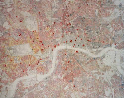
An indication of the relationship between the location of Turkish baths and levels of poverty in London in 1889
The red pins represent Turkish baths known to have opened in London between 1860 and 1901. Although Urquhart, Richard Metcalfe and many others argued for the provision of Turkish baths, free or at a nominal charge, in areas of poverty, the overwhelming majority were located in areas which Booth designated as 'Fairly comfortable', 'Well-to-do' or 'Wealthy'. Many were located near railway stations to catch commuters going home to the suburbs.
Too much should not be inferred from this suggestion. The baths were opened over a period of forty-five years, whereas Booth's map is a snapshot of the situation around 1889. Nevertheless, most of these areas would probably not have changed significantly over this period. Booth did not designate the area of the City of London in which there were thirteen establishments.
A facsimile of Booth's totally fascinating map is still in print and is worth buying!
This page enlarges an image or adds to the information found below:
Early problems and controversies. Part 6: Class
London's first Victorian Turkish bath. Part 4: Charges and class
Victorian Turkish Baths: their origin, development, and gradual decline


Comments and queries are most welcome and can be sent to:
malcolm@victorianturkishbath.org
The right of Malcolm Shifrin to be identified as the author of this work
has been asserted by him
in accordance with the Copyright, Designs and Patents Act 1988
© Malcolm Shifrin, 1991-2023